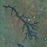
Dosiye:Lakes of Burundi.jpg

Uburinganire bw'iri shushanyo: pixels 800 × 467. Ubundi bwaguke: pixels 320 × 187 | pixels 640 × 374 | pixels 1.017 × 594.
Dosiye nkomoko (pixels 1.017 × 594, uburinganire bwa dosiye: 378 KB, ubwoko bwa MIME: image/jpeg)
Amateka ya dosiye
Fyonda kw'igenekerezo/isaha kugirango urabe dosiye nkuko yagaragaye uwo mwanya.
| Igenekerezo/Isaha | Iparati | Uburinganire | Uwukoresha | Insiguro | |
|---|---|---|---|---|---|
| muri iki gihe | 07:37, 8 Ntwarante 2014 |  | 1.017 × 594 (378 KB) | Peter in s | {{Information |Description ={{en|1=Lakes of north Burundi. Clockwise startet at 9°°: Lake Cohoha (south), Lake Rugwero, Lake Kanzigiri, Lake Rwihinda}} |Source =Worldwind |Author =NASA |Date =2014.03.07 |Permission =... |
Ikoreshwa rya dosiye
Ikoreshwa rya dosiye muri rusangi
Izindi wiki zikurikira zikoresha iyi dosiye:
- Ikoreshwa kuri ca.wikipedia.org
- Ikoreshwa kuri ceb.wikipedia.org
- Ikoreshwa kuri de.wikipedia.org
- Ikoreshwa kuri en.wikipedia.org
- Ikoreshwa kuri es.wikipedia.org
- Ikoreshwa kuri fi.wikipedia.org
- Ikoreshwa kuri fr.wikipedia.org
- Ikoreshwa kuri ha.wikipedia.org
- Ikoreshwa kuri nl.wikipedia.org
- Ikoreshwa kuri ru.wikipedia.org
- Ikoreshwa kuri uk.wikipedia.org
- Ikoreshwa kuri www.wikidata.org


