
Dosiye:Philippines location map.svg

Size of this PNG preview of this SVG file: pixels 454 × 599. Ubundi bwaguke: pixels 182 × 240 | pixels 364 × 480 | pixels 582 × 768 | pixels 776 × 1.024 | pixels 1.552 × 2.048 | pixels 1.871 × 2.468.
Dosiye nkomoko (SVG file, nominally 1.871 × 2.468 pixels, file size: 2,18 MB)
Incamake
| Umwidondoro |
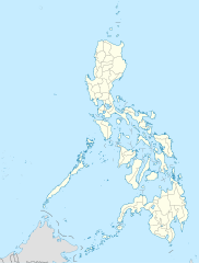
Deutsch: Positionskarte der Philippinen
Quadratische Plattkarte, N-S-Streckung 103 %. Geographische Begrenzung der Karte:
English: Location map of the Philippines
Equirectangular projection, N/S stretching 103 %. Geographic limits of the map:
|
| Igenekerezo | |
| Inkomoko |
own work, using
|
| Umwanditsi | NordNordWest |
| Other versions |
|


|
This map has been made or improved in the German Kartenwerkstatt (Map Lab). You can propose maps to improve as well.
|
Uburenganzira
I, the copyright holder of this work, hereby publish it under the following licenses:

|
Hatanzwe uruhusha rwo kwimura, gukwiragiza canke guhinyanyura ibi vyandiko hakoreshejwe uruhusha rwa GNU Free Documentation License, Umuce wa 1.2 canke umuce uwariwo wose washizeho inyuma ya Free Software Foundation; ata gice ntahinduka, ata majambo y'urupapuro rw'intango canke rw'iherezo. Kwimuru uruhusha biri mu muce witwa GNU Free Documentation License. |
This file is licensed under the Creative Commons Attribution 3.0 Unported license.
- Uridegemvya:
- gusangiza – mukwimura, kwiragiza wongere utange igikorwa
- guhinyanyura – kujanisha igikorwa
- Ku mategeko akurikira:
- umurimo – Utegerezwa gutanga inkuru injanye, tanga umurongo ku ruhushya, kandi erekana ko habaye impinduka. Urashobora kubikora muburyo ubwo aribwo bwose busiguritse, ariko atari mu buryo ubwo aribwo bwose bwerekana ko uwatanze uburenganzira agushigikiye canke ashigikiye ibikoresho vyawe.
Ushobora gucagura uruhusha ushaka.
Amateka ya dosiye
Fyonda kw'igenekerezo/isaha kugirango urabe dosiye nkuko yagaragaye uwo mwanya.
| Igenekerezo/Isaha | Iparati | Uburinganire | Uwukoresha | Insiguro | |
|---|---|---|---|---|---|
| muri iki gihe | 22:17, 25 Ntwarante 2016 | | 1.871 × 2.468 (2,18 MB) | Man77 | upd NIR, Davao |
| 11:46, 14 Gitugutu 2013 |  | 1.871 × 2.468 (2,2 MB) | Hariboneagle927 | fix | |
| 11:07, 14 Gitugutu 2013 |  | 1.871 × 2.468 (2,15 MB) | Hariboneagle927 | fix. Cagayan | |
| 10:58, 14 Gitugutu 2013 |  | 1.871 × 2.468 (2,15 MB) | Hariboneagle927 | Made some update and corrected some minor errors. | |
| 07:22, 9 Gitugutu 2013 |  | 1.871 × 2.468 (2,14 MB) | Hellerick | Regrouped for easier recoloring. | |
| 06:13, 7 Myandagaro 2013 |  | 1.871 × 2.468 (1,07 MB) | Hellerick | Regional division replaced with provincial division. | |
| 19:09, 5 Mukakaro 2009 |  | 1.871 × 2.468 (1.009 KB) | NordNordWest | ||
| 21:04, 25 Rusama 2009 |  | 1.687 × 2.469 (999 KB) | NordNordWest | {{Information |Description= {{de|Positionskarte der Philippinen}} Quadratische Plattkarte, N-S-Streckung 103 %. Geographische Begrenzung der Karte: * N: 21.2° N * S: 4.3° N * W: 115.4° O * O: 127.3° O {{en|Location map of the [[:en |
Ikoreshwa rya dosiye
Urupapuro rukurikira rukoresha iyi dosiye:
Ikoreshwa rya dosiye muri rusangi
Izindi wiki zikurikira zikoresha iyi dosiye:
- Ikoreshwa kuri af.wikipedia.org
- Ikoreshwa kuri als.wikipedia.org
- Ikoreshwa kuri an.wikipedia.org
- Ikoreshwa kuri az.wikipedia.org
- Ikoreshwa kuri be-tarask.wikipedia.org
- Ikoreshwa kuri be.wikipedia.org
- Ikoreshwa kuri bn.wikipedia.org
- Ikoreshwa kuri ce.wikipedia.org
- Ikoreshwa kuri ckb.wikipedia.org
- Ikoreshwa kuri crh.wikipedia.org
- Ikoreshwa kuri cs.wikipedia.org
Raba ikoresha muri rusangi ry'ino dosiye.